Some time ago, I discussed [the engraver and instrument maker Augustine Ryther (fl. 1576–1593)](https://thonyc.wordpress.com/2025/02/26/an-engraver-and-instrument-maker-who-founded-a-dynasty/), who initiated a lineage of instrument makers within the Worshipful Company of Grocers. More recently, I covered [the mariner and maritime atlas creator Sir Robert Dudley (1574–1649)](https://thonyc.wordpress.com/2025/07/23/the-english-aristocratic-bastard-who-advised-the-florentines-on-matters-nautical-and-published-the-first-maritime-atlas-by-an-english-author/), who, after years of service to the Republic of Florence as a nautical consultant, left behind a collection of scientific instruments now residing in the Museo Galileo in Florence. In the latest entry, I focused on one of the British instrument makers who provided Dudley’s instruments, [the Welshman James Kynvyn (c. 1550–1621)](https://thonyc.wordpress.com/2025/08/20/the-welsh-instrument-maker-who-didnt-fit-the-contemporary-mould/). Today, I will examine the English engraver and instrument maker, Charles Whitwell (c. 1568–1611), who also contributed several of those Dudley instruments and was the most prominent apprentice of Augustine Ryther.
Regrettably, as is often the situation with seemingly minor individuals from the realm of practical mathematics during the Early Modern Period, we have almost no information regarding Whitwell’s origins or background. Even the year he was born is estimated based on the presumption that he was fourteen years old when he was appointed as an apprentice to Augustine Ryther, according to the Grocers’ Company records on 17 December 1582. He became a free member of the Grocers’ Company on 10 November 1590.
In the Minutes of the Grocers’ Company from 11 August 1606, it was noted:
> Agreyd that Charles Whitwell grocer shall have the 50l [£50] for ii years wch his brother Robert Whitwell deceased latelie had. And William Whitwell and George Budd salters are allowed his sureties.
This succinct entry indicates that Charles had at least two brothers employed in the City, and they received support from the Grocers’ Company. The Court of Probate granted his widow, Elizabeth, administration of his estate in February 1611/12 (os/ns), implying that Whitwell must have passed away in the latter part of 1611.
This constitutes the entirety of the details[^1] available concerning the life of Charles Whitwell, a figure whom Gerard L’E Turner characterizes as ‘probably the most skilled and versatile instrument maker of the Elizabethan period’.
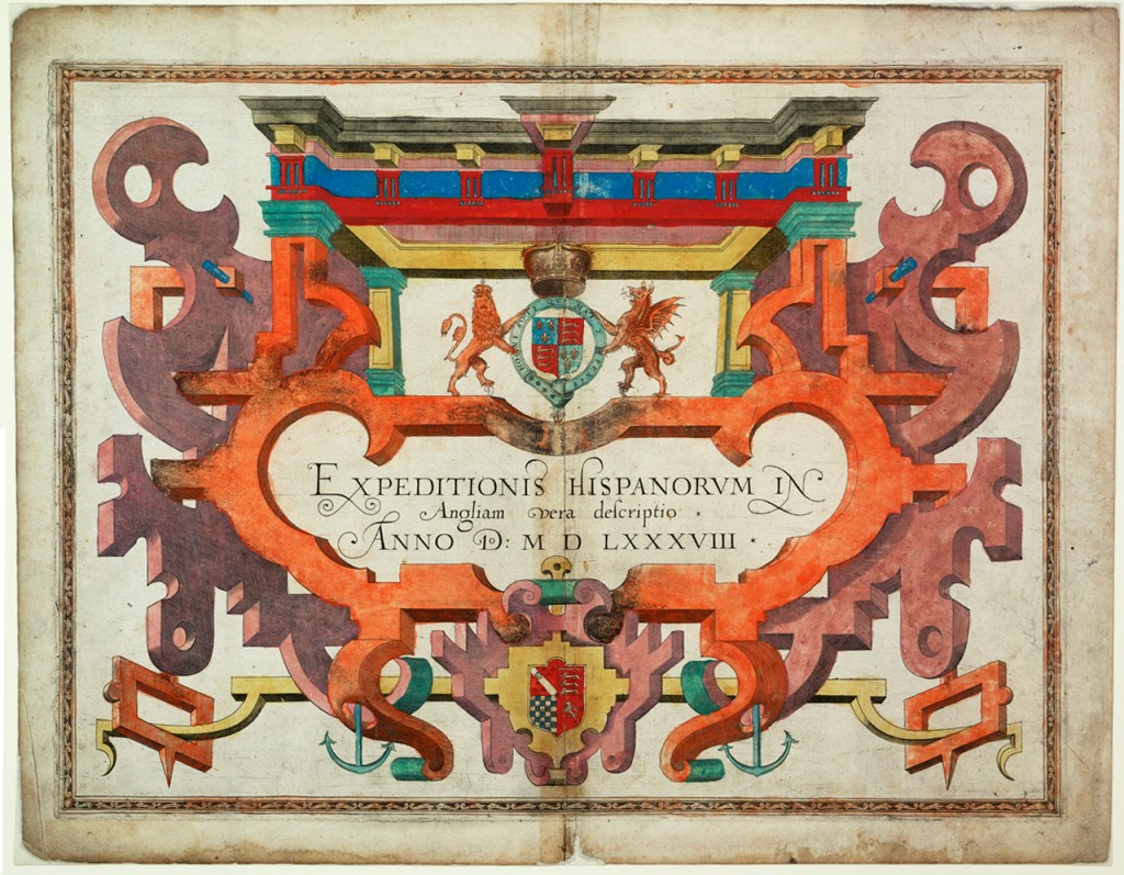
Augustine Ryther gained recognition primarily as a map engraver, exemplified by the series of ten charts depicting the route of the Armada around Britain, which was seemingly illustrated by Robert Adams (1540–1595), the surveyor of the queen’s structures, published in the English translation of *Expeditionis Hispaniorum in Angliam vera Descriptio*, a narrative of the Spanish Armada based on the account compiled by Lord Howard of Effingham (1536–1624), Lord High Admiral, by the mercenary soldier, calligraphist, and illuminator on vellum Petruccio Ubbaldini (c. 1524–c. 1600).
Adams Expeditionis, title page
Indeed, there are only two extant scientific instruments attributed to Ryther. Initially, Whitwell followed in his master’s footsteps as a map engraver.
Ryther was among the engravers of the maps featured in the first English atlas [*The Counties of England and Wales* by Christopher Saxton (c.1540–c. 1610)](https://thonyc.wordpress.com/2018/09/12/saxton-and-speed-two-early-elizabethan-cartographers-and-the-flemish-influence/). Not everyone appreciated Saxton’s work, and the first individual to endeavor to enhance his maps was John Norden (c. 1547–1625).
Norden commenced a series of county histories, each accompanied by a map, titled *Speculum Britanniae*. He only released two volumes from his planned series: *Speculum Britanniae: the First Parte: an Historicall, & Chorographicall Discription of Middlesex*, published in 1593, and *peculi Britaniae Pars: the Description of Hartfordshire published* in 1598. In his unpublished Surrey volume from 1594, the map was engraved by Whitwell. There