Today I’m continuing my occasional series on the English mathematical practitioners of the Early Modern Period. In the post in this series about Edmund Gunter (1581–1626) I quoted the historian of navigation David Waters as follows:
Gunter’s De Sectore & Radio must rank with Eden’s translation of Cortes’s Arte de Navegar and Wright’s Certain Errors as one of the three most important English books ever published for the improvement of navigation.[1]
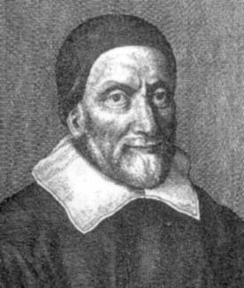
I have already written about Richard Eden (c. 1520–1576) back in 2021, so today I am turning my attention to the third of Water’s trio of navigation improvers, Edward Wright (1561–1615).
As is fairly obvious from the David Waters quote, Edward Wright is one of the most important figures in the history of, not just English but European, navigation during the Early Modern Period. However, as is, unfortunately, all to often the case with mathematical practitioners from this period, we have very little biographical detail about his life and can only fill the gaps with speculation.
The younger son of Henry and Margaret Wright, he was baptised in the village of Garveston in Norfolk on 8 October 1561. His father, a man of “mediocrisfortunae” (modest means), was already deceased, when his elder brother Thomas entered Gonville and Caius College, Cambridge as a pensioner in 1574. Edward was probably educated by John Hayward at Hardingham school, like his elder brother, and also entered Gonville and Caius College, as a sizar, a student who earns part of his fees by working as a servant for other students, in December 1576. Unfortunately, Thomas died early in 1579. Edward graduated BA in the academic year 1580-81 and MA in 1584. He became a fellow of Gonville and Caius in 1587 and resigned his fellowship in 1596, having married Ursula Warren (died 1625) 8 August 1595. Oxbridge fellows were not permitted to marry. They had a son Thomas Wright (1596–1616), who was admitted sizar at Gonville and Caius in 1612.
Wright’s career in Cambridge parallels that of another significant mathematical practitioner born in the same year, Henry Briggs (1561–1630). Briggs went up to St John’s College in 1577, graduated BA in 1581 or 1582 and MA in 1585. He was awarded a fellowship in 1588. The two became friends and interacted over the years up till Wright’s death.

Another acquaintance of Wright’s, who he possibly got to know at Cambridge, was the aristocrat Robert Devereux (1565–1601), who graduated MA at Trinity College Cambridge in 1581, and who had succeeded to the title of Earl of Essex in in 1576 at the death of his father. Devereux, a soldier, was incredibly well connected in Elizabethan society becoming a favourite at Elizabeth’s Court and so would initially have been a good contact for the commoner Wright. However, he was still a close friend of Wright’s when he rebelled against Elizabeth at the end of the century, which could have proved dangerous for the mathematical practitioner, but apparently didn’t.

Another soldier and a good friend of Devereux’s, who also became a friend of Wright’s at Cambridge, was the astronomer and astrologer, Sir Christopher Heydon (1561–1623), who graduated BA in 1789 at Peterhouse Cambridge.

What we don’t know is who taught Edward Wright mathematics at Cambridge and how, why, and when he became deeply interested in navigation and cartography, which he very obviously did, whilst still at the university. The interest in sea voyages and all things navigational associated with them was very strong in England in the latter part of the sixteenth century, with England beginning to flex its deep-sea muscles and challenge the Spanish Portuguese duopoly on marine exploration and discovery, particularly following the defeat of the Spanish Armada in 1588. This could well have been Wright’s motivation as a mathematical practitioner to follow the lead of other practitioners such as John Dee (1527–1608/9) and Thomas Harriot (c. 1560–1621) and specialise in navigation.
That Wright had taken up the study of navigation and already acquired a substantial reputation is indicated by the Royal Mandate, issued by Elizabeth in 1589, instructing Gonville and Caius College to grant Wright leave of absence to carry out navigational studies on a raiding expedition to the Azores under the command of Sir George Clifford, 3rd Earl of Cumberland (1588–1605).

Cumberland was sailing as what is known as a privateer, which means piracy licensed by the Crown in exchange for a share of the profits. Sailing to the Azores, on the way Cumberland seized French Catholic league and Flemish vessels. In the Azores he attacked both the islands and various Portuguese and Spanish vessels making rich killings. Up till now, the expedition was a success, but the return journey was pretty much a disaster. Hit by storms many of the crew died of hunger and thirst on the return journey and the English ship the Margaret was shipwrecked off the coast of Cornwall. All the while Wright was carrying out his navigational studies. On the voyage he was accompanied by Richard Hues (1553–1632) a cartographical and navigational pupil of Thomas Harriot and one of the Wizard Earl’s mathematici. He also became acquainted with the navigator and explorer John Davis (c. 1550–1605).

Wright recorded his experiences of the Azores’ voyage in his most important publication: Certaine Errors in Navigation, arising either of the Ordinarie Erroneous Making or Vsing of the Sea Chart, Compasse, Crosse Staffe, and Tables of Declination of the Sunne, and Fixed Starres Detected and Corrected. (The Voyage of the Right Ho. George Earle of Cumberl. to the Azores, &c.), London: Printed … by Valentine Sims.

Another version of the work published in the same year was entitled: Wright, Edward (1599), Errors in nauigation 1 Error of two, or three whole points of the compas, and more somtimes, by reason of making the sea-chart after the accustomed maner … 2 Error of one whole point, and more many times, by neglecting the variation of the compasse. 3 Error of a degree and more sometimes, in the vse of the crosse staffe … 4 Error of 11. or 12. minures in the declination of the sunne, as it is set foorth in the regiments most commonly vsed among mariners: and consequently error of halfe a degree in the place of the sunne. 5 Error of halfe a degree, yea an whole degree and more many times in the declinations of the principall fixed starres, set forth to be obserued by mariners at sea. Detected and corrected by often and diligent obseruation. Whereto is adioyned, the right H. the Earle of Cumberland his voyage to the Azores in the yeere 1589. wherin were taken 19. Spanish and Leaguers ships, together with the towne and platforme of Fayal, London: Printed … [by Valentine Simmes and W. White] for Ed. Agas.
Before we turn to the navigational errors that Wright illuminated in his book, it also contains another piece of interesting information. Wright states that he sailed with Cumberland under the name Edward Carelesse. When he introduces himself in the book, he also states that he sailed with Sir Francis Drake, as Captain of the Hope, on his West Indian voyage of 1585-86, which evacuated Sir Walter Raleigh’s Virginia colony and brought the survivors back to England. Wright would have had the opportunity to make the acquaintance of Thomas Harriot, who was one of the rescued colonists. Capt. Walter Bigges and Lt. Crofts’ book A Summarie and True Discourse of Sir Frances Drakes West Indian Voyage (1589) confirms that Edward Carelesse was commander of the Hope. This voyage would fit into the gap between Wright’s MA, 1585 and the start of his fellowship in 1587.
The principal navigational error that Wright’s book addresses, and the reason why it is so important, is the problem of sailing the shortest route between two places on a sea voyage. In the early phase of European deep-sea exploration, mariners adopted the process of latitude sailing. Mariners could not determine longitude but could determine latitude fairly easily. Knowing the latitude of their destination they would sail either north or south until they reached that latitude and then sail directly east or west until they reached their desired destination. This was by no means the most direct route but prevented getting lost in the middle of the ocean.
The actual shortest route is a great circle, that is a circumference of the globe passing through both the point of departure and the destinations. However, it is very difficult to sail a great circle using a compass as you have to keep adjusting you compass bearing. Although not as short, far more practical for mariners would be a course that is a constant compass bearing, such a course is known as a rhumb line, rhumb, or loxodrome:
In navigation, a rhumb line, rhumb, or loxodrome is an arc crossing all meridians of longitude at the same angle, that is, a path of constant bearing as measured relative to true north. (Wikipedia)

The first to analyse the mathematics of rhumb lines, which takes the form of a spiral on the surface of a sphere, was the Portuguese mathematical practitioner Pedro Nunes (1502–1578) in his Tratado em defensam da carta de marear (Treatise Defending the Sea Chart), (1537).

Nunes determined that a course of constant bearing would be a rhumb, but he did not solve the problem of how to construct a marine chart on which a rhumb line would be a straight-line enabling navigators to simple read off the required compass bearing from the chart. This problem was first solved by the Flemish globe maker and cartographer, Gerard Mercator (1512–1594), who was friends with Nunes, with the publication of his world map of 1569, which introduced for the first time what is now known as the Mercator projection on which a course of constant compass bearing is a straight line.

Mercator explained in simple terms how he had achieved this, “We have progressively increased the degrees of latitude towards each pole in proportion to the lengthenings of the parallels with reference to the equator” but gave no exact mathematical prescription how to produce such a chart.

Both John Dee (1527–1609?), who personally knew Pedro Nunes and studied cartography under Mercator’s teacher Gemma Frisius (1508–155) and Thomas Harriot (c. 1560–1621) solved the problem of how to mathematically construct the Mercator projection. However, although both of them taught cartography and navigation, Dee to the captains of the Muscovy Trading Company and Harriot to Walter Raleigh’s captains, neither of them made their solution public. Enter Edward Wright.
Wright took up the problem of the marine chart and rhumb lines where Pedro Nunes had stopped, openly acknowledging his debt to Nunes in the preface to his Certaine Errors in Navigation:

Yet it may be, I shall be blamed by some, as being to busie a fault-finder myself. For when they shall, see their Charts and other instruments controlled which so long time have gone for current, some of them perhappes will scarcely with pacience endure it. But they may be pacified, if not by reason of the good that ensueth hereupon, yet towards me at the least because the errors I poynt at in the chart, have beene heretofore poynted out by others, especially by Petrus Nonius, out of whom most part of the first Chapter of the Treatise following is almost worde for worde translated;
He goes on to solve the problem of constructing the Mercator projection:
By help of this planisphaere with the meridians, rumbes, and parallels thus described therein, the rumbs may much more easily & truly be drawn in the globe then by these mechanical wayes which Petrus Nonius [Pedro Nunes] teacheth cap. 26 lib. 2 de obser. Reg. et Instr. Geom..
The problem that Wright solved is that as one proceeds north or south from the equator the circles of latitude get progressively smaller but when one unwraps the globe on the surface of a cylinder in the Mercator projection all the lines of latitude need to be the same length so that they cross all lines of latitude at right angles.

Wright’s principle was very simple: to increase the distance apart of the parallels of latitude to match the exaggeration arising from the assumption that they were equally long. Since the lengths of the parallels varied according to a factor cos λ, the correction factor was sec λ at any point. In order to plot the parallels on the new charts, Wright had effectively to perform the integration’ sec λdλ. This was done numerically—in his own words, “by perpetual addition of the Secantes answerable to the latitudes of each point or parallel into the summe compounded of all the former secantes. . . .,” (P. J. Wallace, Dictionary of Scientific Biography)
To save others having to repeat the protracted and tedious numerical iterations that he had carried out, Wright published a table of the necessary correcting factors for the distance between the lines of latitude. In the first edition of the book this table was only six pages long and contained the correction factors for every 10 minutes of latitude. In the second edition of the book, Certaine Errors in Navigation, Detected and Corrected with Many Additions that were not in the Former Edition…, published in London in 1610, the table had grown to 23 pages with factors for every minute of latitude.

The emergence of both Wright’s book and his method of constructing the Mercator projection into the public sphere is rather complex. He obviously wrote the major part of the manuscript of the book when he returned to Cambridge in 1598 but there are sections of the book based on observation made in London between 1594 and 1597. Wright’s development of the Mercator projection was first published, with his consent, in Thomas Blundevile’s His Exercises containing six Treatises in 1594, the first publication in English on plane trigonometry, he wrote:

[the new (Mercator) arrangement, which had been constructed] “by what rule I knowe not, unless it be by such a table, as my friende M.Wright of Caius College in Cambridge at my request sent me (I thanke him) not long since for that purpopse which table with his consent. I have here plainlie set down together with the use of thereof as followeth”. The table of meridiional parts was given at degree intervals.
The Dutch engraver and cartographer Jodocus Hondius (1563–1612), who in his time in London had obviously had access to Wright’s work, published his “Christian Knight World Map” based on Wright’s calculations without acknowledgement in 1597.

Although he wrote a letter of apology to Wright, Wright condemned him for it in the preface to Certaine Errors:
“But the way how this [Mercator projection] should be done, I learned neither of Mercator, nor of any man els. And in that point I wish I had beene as wise as he in keeping it more charily to myself”
Hondius was by no means the only one to publish Wright’s method before he himself did so. William Barlow (1544–1625) included in his The Navigator’s Supply (1597) a demonstration of Wright’s projection “obtained of a friend of mone of like professioin unto myself”.

In 1598–1600 Richard Hakluyt published his Principle Navigations which contains two world charts on the new projection, that of 1600 a revision of the first. Although not attributed to Wright it is clear that they are his work.


Earlier, the navigator Abraham Kendall had borrowed a draft of Wright’s manuscript and unknown to Wright made a copy of it. He took part in Drake’s expedition to the West Indies in 1595 and died at sea in 1596. The copy was found in his possessions and believing it to be his work it was brought to London to be published. Cumberland showed the manuscript to Wright, who, of course recognised it as his own work.
Wright first publicly staked his claim to his work when he finally published the first edition of Certaine Errors in 1599. A claim that he reinforced with the publication of the second, expanded edition in 1610. However, it should not be assumed that mariners all immediately began to use Mercator projection sea charts for navigating. The acceptance of the Mercator marine chart was a slow process taking several decades. As well the method of producing the Mercator projection, Certaine Errors also includes other useful information on the practice of navigation such as a correction of errors arising from the eccentricity of the eye when making observations using the cross-staff, tables of declinations, and stellar and solar observations that he had made together with Christopher Haydon. The work also includes a translation of Compendio de la Arte de Navegar (Compendium of the Art of Navigation, 1581, 2nd ed., 1588) by the Spanish cosmographer Rodrigo Zamorano (1542–1620).
It is not clear how Wright lived after he had resigned from his fellowship. There are suggestions that he took up the position of Mathematicall Lecturer to the Citie of London when Thomas Hood resigned from the post after only four years in 1592. However, there is no evidence to support this plausible suggestion. Wright’s friend, Henry Briggs, was appointed the first Gresham professor of geometry in 1596, a position to hold public lectures also in London, which may have made the earlier lectureship superfluous. However, Wright was definitely employed by Thomas Smith and John Wolstenholme, who had sponsored Hood’s lectureship, as a lecturer in navigation for the East India Company at £50 per annum, probably from 1612 but definitely from 1614. Before his employment by the East India Company, he had been mathematical tutor to Prince Henry (1594–1612), the eldest son of King James I/IV, from about 1608, to whom he dedicated the second edition of Certaine Errors.
In the 1590s Wright was one of the investigators whose work contributed to William Gilbert’s De Magnete(1600) for which he wrote the opening address on the author and according to one source contributed Chapter XII of Book IV, Of Finding the Amount of Variation…


In this context he also wrote, Description and Use of the Two Instruments for Seamen to find out the Latitude … First Invented by Dr. Gilbert, published in Blundeville, Thomas; Briggs, Henry; Wright, Edward (1602),The Theoriques of the Seuen Planets… a work on the dip circle.
He also authored The Description and Vse of the Sphære. Deuided into Three Principal Partes: whereof the First Intreateth especially of the Circles of the Vppermost Moueable Sphære, and of the Manifould Vses of euery one of them Seuerally: the Second Sheweth the Plentifull Vse of the Vppermost Sphære, and of the Circles therof Ioyntly: the Third Conteyneth the Description of the Orbes whereof the Sphæres of the Sunne and Moone haue beene supposed to be Made, with their Motions and Vses. By Edward Wright. The Contents of each Part are more particularly Set Downe in the Table first published in London in 1613 with a second edition in 1627. This could be viewed as a general introduction to the armillary sphere, but was actually written was a textbook for Prince Henry. A year later he published A Short Treatise of Dialling Shewing, the Making of All Sorts of Sun-dials, Horizontal, Erect, Direct, Declining, Inclining, Reclining; vpon any Flat or Plaine Superficies, howsoeuer Placed, with Ruler and Compasse onely, without any Arithmeticall Calculationprobably also written for the Prince.
As well as the translation of Zamorano’s Compendio de la Arte de Navegar included in his Certaine Errors, he translated Simon Stevin’s The Hauen-finding Art, or The VVay to Find any Hauen or Place at Sea, by the Latitude and Variation. Lately Published in the Dutch, French, and Latine Tongues, by Commandement of the Right Honourable Count Mauritz of Nassau, Lord High Admiral of the Vnited Prouinces of the Low Countries, Enioyning all Seamen that Take Charge of Ships vnder his Iurisdiction, to Make Diligent Obseruation, in all their Voyages, according to the Directions Prescribed herein: and now Translated into English, for the Common Benefite of the Seamen of England, a text on determining longitude using magnetic variation.

In 1605, he also edited Robert Norman’s translation out of Dutch of The Safegarde of Saylers, or Great Rutter. Contayning the Courses, Dystances, Deapths, Soundings, Flouds and Ebbes, with the Marks for the Entring of Sundry Harboroughs both of England, Fraunce, Spaine, Ireland. Flaunders, and the Soundes of Denmarke, with other Necessarie Rules of Common Nauigation.
His most important work of translation was certainly that of John Napier’s Mirifici Logarithmorum Canonis Descriptio (Description of the Wonderful Canon of Logarithms, 1614) from the original Latin into English: A Description of the Admirable Table of Logarithmes: With a Declaration of the … Use thereof. Invented and Published in Latin by … L. John Nepair … and Translated into English by … Edward Wright. With an Addition of an Instrumentall Table to Finde the Part Proportionall, Invented by the Translator, and Described in the Ende of the Booke by Henry Brigs, etc approved by Napier and first published posthumously by Henry Briggs in 1616 and then again in 1618.

The development of mathematical navigation, cartography, and surveying in the Early Modern Period, in which Wright along with others played a central role, was by nature predominantly trigonometrical. Napier’s invention of logarithms made the complex trigonometrical calculations much easier to manage. This was something that Napier himself was acutely aware of and the majority of tables in his work were, in fact, logarithms of trigonometrical functions. By translating Napier’s work into English, Wright made it accessible to those mariners confronted with trigonometrical navigational problems, who couldn’t read Latin. The introduction contains the following poem:
The toylesome rules of due proportion
Done here by addition and subtraction,
By tripartition and tripartition,
The square and cubicke roots extraction:
And so, all questions geometricall,
But with most ease triangles-sphericall.
The use in great in all true measuring
of lands, plots, buildings, and fortification,
So in astronomy and dialling,
Geography and Navigation.
In these and like, yong students soon may gaine
The skilfull too, may save cost, time, & paine.
Wright was also acknowledged as a skilled designer of scientific instruments, but like his friend Edmund Gunter (1561–1626), he didn’t make them himself. He is known to have designed instruments for the astronomer/astrologer Sir Christopher Haydon and to have made astronomical observations with him in London in the early 1590s. We don’t know Wright’s attitude to astrology, but that of his two Cambridge friends was diametrically opposed. Haydon was the author of the strongest defence of astrology written in English in the early seventeenth century, his A Defence of Judiciall Astrologie (1603), whereas Henry Briggs was one of the few mathematical practitioners of the period, who completely rejected it, unlike John Napier who as an ardent supporter.
Wright work in navigation was highly influential on both sides of the North Sea.
His work formed the basis of the navigation treatise Tiphys Batavus (1624) of the Netherlander mathematical practitioner Willebrord Snel (1580–1626),

as well as the Primum mobile astronomice, sciographice, geometrice & hydrographice nova methodo explicatum of his student Adriaan Adriaanszoon Metius (1571–1635) son of the mathematical practitioner Adriaan Anthoniszoon (1541–1620) and brother of Jacob Metius (1572–1628) one of the inventors of the telescope. Wright’s friend Edmund Gunter included a scale for the meridional parts of the Mercator chart on his sector.

Wright gets positively acknowledge, both in The Navigator (1642) by Charles Saltonstall (1607–1665) and in the Navigation by the Mariners Plain Scale New Plain’d (1659) by John Collins (1625–1683).
In England Wright’s work was also taken up by Richard Norwood (1590? –1675), the surveyor of Bermuda, who using Wright’s methods determined one degree of a meridian to be 367,196 feet (111,921 metres), surprisingly accurate, publishing the result in his The Seaman’s Practice, 1637. However, in his Norwood’s Epitomy, being the Application of the Doctrine of Triangles, 1645, he gives a clear sign that the Mercator chart still hasn’t been totally accepted 46 years after Wright first published the solution of how to construct it.
Although the ground of the Projection of the ordinary Sea-Chart being false, (as supposing the Earth and Sea to be plain Superficies [sufaces]) and so the conclusions thence derived must also for the most part erroneous; yet because it is most easy, and much used, and the errors in small distances not so evident, we will not wholly neglect it.
He actually devotes as much space, in this work, which continued to be published throughout the century in various editions, to plain sailing as he does to Mercator sailing. Interestingly in the section on Mercator sailing, he doesn’t, following Wright, just give a table of meridional parts but explains how to use trigonometry to calculate them.
Now that which he [Edward Wright] hath shewed to performe by the Chart it selfe [the table of meridional parts], we will shew to work by the Doctrine of plaine Triangles, using the helpe of the Table of Logarithme Tangents…

Although its impact was drawn out over several decades it is impossible to over emphasise Wright’s contribution to the histories of cartography and navigation by his publication of the mathematical means of constructing a Mercator chart.
[1] David Walters, The Art of Navigation in England in Elizabethan and Early Stuart Times, Yale University Press, 1958 p. 359