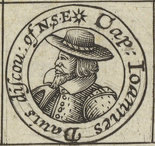
Regular readers of my series of posts on English mathematical practitioners in the late sixteenth and early seventeenth centuries might have noticed the name John Davis popping up from time to time. Unlike most of the other mathematical practitioners featured here in the early modern history of cartography, navigation, and scientific instrument design, who were basically mathematicians who never or seldom went to sea, John Davis (c. 1550–1605) was a mariner and explorer, who was also a mathematician, who wrote an important and widely read book on the principles of navigation, which included the description of an important new instrument that he had designed.
John Davis was born and grew up in Sandridge Barton, the manor farm on the Sandrige Estate of Stoke Gabriel in Devon, a small village on the river Dart about six kilometres up-river from Dartmouth, which was an important port in the early modern period, so it seems that Davis was destined to go to sea. Amongst his neighbours, on the Sandrige Estate, were the five sons of the Gilbert-Raleigh family, Humphrey, John and Adrian Gilbert and their half brothers Carew and Walter Raleigh. Both Humphrey Gilbert (c. 1539–1583) and Walter Raleigh (c. 1552–1618) were important Elizabethan explorers and Carew Raleigh (c. 1550–c. 1625) was a naval commander. Adrian Gilbert (c. 1541–1628), who became an MP was an intimate friend of the young John Davis as was Walter Raleigh. Little is known of his childhood and youth, but we do know that he early became a friend and pupil of the leading Elizabethan mathematical practitioner, John Dee (1527–c. 1608). Davis’ friendship with the Gilbert-Raleigh brothers and John Dee would prove helpful in his first major exploration endeavour, the search for the Northwest Passage.


Throughout the Middle Ages, Europe had imported good, in particular spices, from Asia via a complex, largely overland route that ended in Northern Italy, from whence the city of Nürnberg distributed them all over Europe. As the European began to venture out onto the high seas in the fifteenth century, the question arose, whether it was possible to reach Asia directly by sea? The Portuguese began to edge their way down the West African coast and in 1487/88 Bartolomeu Dias (c. 1450–1500) succeeded in rounding the southern end of Africa.

Between 1479 and 1499 Vasco da Gama (c. 1460–1524) succeeded, with the help of an Arabic pilot, in crossing the Indian Ocean and bringing back a cargo of spices from India to Portugal. This established an initial Portuguese dominance over the oceanic route sailing eastwards to Asia, which with time they extended to the so-called Spice Islands.

As every school kid knows, Christopher Columbus (1451–1506) believed that there was open water between the west coast of Europe and east coast of China, and that he could reach Asia faster and easier sailing west across the ocean rather the east around Africa. In 1492, he put his theory to the test and, having vastly underestimated the distance involved, just as he was running out of food, his small fleet fortuitously ran into the Americas, although they weren’t called that yet. In 1519, the Spanish seaman Ferdinand Magellan (1480–1521) proved it was possible to get past the southern tip of America and into the Pacific Ocean. The last remnants of his very battered fleet returning to Spain, without Magellan, who was killed on the way, in 1522, becoming the first people to circumnavigate the globe.
In 1577, Francis Drake (c. 1540–1596) set out to attack the Spanish on the west coast of the America, decided to return via the Pacific Ocean arriving back in England in 1580, becoming the second to circumnavigate the globe, and the first commander to survive the journey. Between 1586 and 1588, Thomas Cavendish (1560-1592), a protégé of Walter Raileigh, became the third man to circumnavigate the globe, on what was the first planned voyage to do so.

The successful circumnavigations via the southern tip of the Americas led to speculation whether it was possible to reach the Pacific Ocean by rounding the northern end of the Americas. These speculations led to the search for the so-called Northwest Passage, an endeavour in which English mariners would dominate.
Already in 1497, Henry VII sent the Italian mariner, John Cabot (C. 1450–c. 1500) to attempt to find the Northwest Passage. He is thought to have landed once somewhere on the coast of what is now Canada before returning to Bristol. In 1508, Cabot’s son Sebastian (c. 1474–1557) followed his father in trying to find the Northwest Passage. He is thought to have sailed as far north as Hudson Bay. In 1524, the Portuguese mariner, Estêvão Gomes (c. 1483–1538), who had mutinied on the Magellan circumnavigation, bringing his ship back to Spain in 1521, was commissioned by the Spanish Crown to seek a northern route through the Americas, reaching Nova Scotia before returning to Spain.
In 1551, the Muscovy Trading Company was founded in London with the specific intention of finding a Northeast Passage to China by sailing around the northern coast of Russia. A project for which they were granted exclusive rights by the English Crown. The Muscovy Company employed John Dee to teach cartography and navigation to its ships’ officers. They failed in their endeavour to find the Northeast Passage but did establish successful trading deals with Russia.

In the 1560s Humphrey Gilbert wrote a detailed treatise supporting the idea of a government supported endeavour to search for the Northwest Passage. In 1574, the privateer Martin Frobisher (c. 1535–1594) petitioned the Privy Council for permission and financial support for an expedition to find the Northwest Passage. They referred him to the Muscovy Company, who eventually agreed to licence his voyage. Altogether Frobisher undertook three attempts, in 1596 with three ships, in 1597 with a much larger fleet and finally in 1578 with a total of fifteen ships. Although he explored much of the coast and islands of Northern Canada the undertaking was basically an expensive flop. On the second expedition Frobisher’s master was Christopher Hall. Frobisher and Hall were coached by Dr John Dee in geometry and cosmography in order to improve their use of the instruments for navigation in their voyage.

In 1583, Humphrey Gilbert launched an attempt, based on letters patent, that he had acquired from the crown in 1578, to establish an English colony in North America. His half-brother Walter Raleigh sailed with him but had to turn back due to lack of food on his ship. Having taken possession of Newfoundland by force, he then left again without establishing a colony due to lack of supplies. The return journey was a disaster with the loss of the biggest vessel with most of there stores and Gilbert died of blood poisoning, having stepped on a nail.

The only halfway positive outcome was that Walter Raleigh received a royal charter based on Gilbert’s letters patent and would in turn go on to found, with Thomas Harriot (c. 1560–1621), as his cartography and navigation advisor, the first English colony in North America on Roanoke Island in 1584. Only halfway positive because the Roanoke colony was also a failure.
It was against this background of one hundred years of failure, from John Cabot to Martin Frobisher, to find a northwest passage that John Davis became involved in the launching of yet another expedition to find one, initiated by his childhood friend Adrian Gilbert and John Dee. Gilbert and Dee, appealed to Sir Francis Walsingham (1573–1590) Secretary of State for funding in 1583. Whilst Walsingham favoured the idea politically, no money from the state was forthcoming. Instead, the planned expedition was financed privately by the London merchant, William Sanderson (c.1548–1638).
Sanderson was trained by Thomas Allen, an assistant to the Muscovy Company, who supplied the Queen’s Navy with hemp, rope, flax, and tallow, which he imported from the Baltic countries. As a young man, Sanderson travelled with Allen throughout the Baltic, France, Germany, and the Netherlands. According to his son, he became wealthy when he inherited the family estates following the death of his elder brother. In either 1584 or 1585 he married Margaret Snedall, daughter of Hugh Snedall, Commander of the Queen’s Navy Royal, and Mary Raleigh sister to Walter Raleigh. Sanderson would go on to become Walter Raleigh’s financial manager.
Here we have once again a merchant financing exploration in the early stumbling phase of the British Empire, a concept that was first floated by John Dee and was propagated by the various members of the Gilbert-Raleigh clan. As we saw in an earlier post, it was the merchants Thomas Smith and John Wolstenholme, who later founded the East India Trading Company, who financed the mathematical lectures of Thomas Hood (1556–1620). Above, we saw that the Muscovy Trading Company financed Frobisher’s efforts to find the Northwest Passage. The founding of the British Empire was driven by trade, and it remained a trading empire throughout its existence. Trade in spices, gold, opium, tea, slaves and other commodities drove and financed the existence of the Empire.
Davis led three expeditions in search of the Northwest Passage in 1585, 1586, and 1587. He failed to find the passage but carried out explorations and surveys of much territory between Greenland and Northern Canada liberally spraying the map with the names of Sanderson, Raleigh, and Gilbert. On these voyages Davis proved his skill as a navigator and marine commander, his logbooks being a model for future mariners and although the expeditions failed in their main aim, they can certainly be counted as successful.

In 1588 he is thought to have commanded the Black Dog against the Spanish Armada. In 1589 he was part of the Earl of Cumberland’s voyage to the Azores and became acquainted with Edmund Wright.

In 1591, he was part of Thomas Cavendish’s voyage to attempt to find the Northwest Passage from the western end in the Pacific. The voyage was a disaster, Cavendish losing most of his crew in a battle with the Portuguese and setting sail for home. Davis carried on to the Straits of Magellan but was driven back by bad weather, also turning for home. He too lost most of his crew on the return journey but is purported in 1592 to be the first English man to discover the Falkland Islands, a claim that is disputed.
Davis sailed as master with Walter Raleigh on his voyages to Cádiz and the Azores in 1596 and 1597. He sailed as pilot with a Dutch expedition to the East Indies between 1598 and 1600. From 1601 to 1603 he was pilot-major on the first English East India Company voyage led by Sir James Lancaster (c. 1554–1618), a privateer and trader.


Although a success, the voyage led to a dispute between Davis and Lancaster, the later accusing the pilot of having supplied false information on details of trading. Annoyed, Davis sailed in 1604 once again to the East Indies as pilot to Sir Edward Michelbourne (c. 1562–1609) an interloper who had been granted a charter by James I & VI despite the East India Company’s crown monopoly on trade with the East. On this voyage he was killed off Singapore by a Japanese pirate whose ship he had seized. Thus, ending the eventful life of one of Elizabethan England’s greatest navigators.
All the above is merely an introduction to the real content of this post, Davis’ book on navigation and his contribution to the development of navigation instruments. However, this introduction should serve to show two things. Firstly, that when Davis wrote about navigation and hydrography, he did so as a highly experienced mariner and secondly just how incestuous the exploration and navigation activities in late sixteenth century England were.
In 1594, Davis published his guide to navigation for seamen, which could with some justification be called Navigation for Dummies. It was the first book on navigation actually written by a professional navigator. To give it its correct title:
THE SEAMAN’S SECRETS; Deuided into 2, partes, wherein is taught the three kindes of Sayling, Horizontall, Peradoxal, and sayling vpon a great Circle: also an Horizontall Tyde Table for the easie finding of the ebbing and flowing of the Tydes, with a Regiment newly calculated for the finding of the Declination of the Sunne, and many other necessary rules and Instruments, not heretofore set foorth by any.
Newly published by Iohn Dauis of Sandrudge, neere Dartmouth, in the County of Deuon. Gent.
Imprinted at London by Thomas Dawson, dwelling at the three Cranes in the Vinetree, and are these to be solde. 1595

David Waters write, “his work gives in the briefest compass the clearest picture of the art of navigation at this time.”[1]
Davis defines his three kinds of sailing thus:
Horizontal [plane] Navigation manifesteth all the varieties [changes] of the ship’s motion within the Horizontal plain superfices [on a plane chart], where every line [meridian] is supposed parallel.
This was the traditional and most common form of navigation at the time Davis wrote his book and he devotes the whole of the first part of the book to it.
Paradoxal Navigation demonstrateth [on circumpolar charts] the true motion of the ship upon any corse assigned … neither circular nor strait, but concurred or winding … therefore called paradoxal, because it is beyond opinion that such lines should be described by plain horizontal motion.
What Davis is defining here is rhumb line or Mercator sailing.
Great circle navigation he considered as the ‘chiefest of all the three kinds of sayling’, and defined it as one ‘in whom all the others are contained … continuing a corse by the shortest distance between places not limited to any one corse.’
He lists the instruments necessary for a skilful seaman:
A sea compass, a cross staff, a quadrant, an Astrolaby, a chart, an instrument magnetical for finding the variations of the compass, an Horizontal plain sphere, a globe and a Paradoxal compass.
He then qualifies the list:
But the sea Compass, Chart and Cross Staff are instruments sufficient for the Seaman’s use … for the Cross Staffe, Compass and the chart are so necessarily joined together as that the one say not well be without the other … for as the Chart sheweth the courses, so doth the compasse direct the same, and the cross-staffe by every particular observed latitude doth informe the truth of such course, and also give the certaine distance that the ship hath sayled upon the same.

Davis describes the technique of plane (horizontal) sailing as–’the god observation of latitude, careful reckoning of the mean course steered (corrected for variation), and careful estimation of the distance run’. Of these ‘the pilot has only his height [latitude] in certain.’[2]
Davis gives clear definition of special terms such as course and traverses and delivers an example of how he wrote up his ship’s journal. His was the first book published to give such things.


He gave much space to how to calculate the tides, including the use of ‘An Horizontal Tyde-Table,’ an instrument for calculating tide times.
Davis goes into a lot of details on how to calibrate the cross-staff, he paid particular attention to the problem of parallax produced by placing the end of the cross-staff in the wrong position on the face. This is interesting given his development of the back-staff.
In order to determine one’s latitude, it was necessary to determine the altitude of the sun at noon. This was usually done using a cross-staff, also known as a Jacob’s staff, but could also be done with a quadrant or a mariner’s astrolabe.

The cross-staff suffered from a couple of problems. As well as the eye parallax problem, already discussed, the user had to hold the staff so that the lower tip of the traverse rested on the horizon, whilst the upper tip was on the sun, then the angle of altitude could be read off on the calibrated scale on the staff. There were different sized traverses for different latitudes and there were scales on the staff for each traverse, a topic that Davis delt with in great detail. It was difficult for the user to view both tips at the same time. Added to this the user was basically staring directly into the sun.

To get round these problems Davis invented the backstaff. At the end of the staff was a horizon vane through which the user viewed the horizon with his back to the sun. An arc, ewith a shadow vane, was attached to the staff which could slide back and forth until its shadow fell on the horizon vane the angle of altitude could be read off on the calibrated staff. This staff did not suffer from the eye parallax problem, the user only had to observe the horizon and not the sun at the same time, and the user did not have to look directly into the sun.


Davis’ original back staff could only measure a maximum angle of altitude of 45°, which was OK as long as he was sailing in the north but was too small when he started sailing further south, so he developed a more advanced model that could measure angles up to 90°.


This evolved over time into the so-called Davis quadrant.


Better than the cross-staff for measuring the sun’s altitude, the back-staff became the instrument of choice, particularly for English mariners for more than a century, but it was not perfect. Unlike the cross-staff, it could not be used at night to determine latitude by measuring stellar altitudes, also its use was limited by overcast weather when the sun was not strong enough to cast a shadow. To help with the latter problem, John Flamsteed replaced the shadow vane with a lens that focused the sunlight on the horizon vane instead of a shadow. The weak sunlight focused by the lens could be better seen that the faint shadow. The backstaff with lens evolved into the Hadley quadrant, which in turn evolved into the sextant still in use today.
Davis also gives an extensive description of how to navigate using a terrestrial globe. This was very innovative because mass produced printed globes were a fairly recent invention, Johannes Schöner (1477–1547) produced the first serial printed terrestrial globe in 1515, and were not easy to come by. It was Davis, who persuaded his own patron, William Sanderson, to finance Emery Molyneux’s creation of the first printed terrestrial and celestial globes in England in 1592.

Davis emphasised that the terrestrial globe was particularly good for instruction in navigation because all three forms of sailing–plane, rhumb line, great circle–could be demonstrated on it.
In his original list of instruments for the seaman, Davis included the Paradoxal compass but he doesn’t actually explain anywhere what this instrument is. John Dee, who remember was John Davis’ teacher, also mentions the Paradoxal compass in his writings without explanation. There is talk of how he created a Paradoxal chart for Humphrey Gilbert for his fatal 1583 expedition. It turns out that the Paradoxal compass and Paradoxal chart are one and the same and that it is an azimuthal equidistant circumpolar chart, with the north pole at its centre and the lines of latitude at 10° interval as concentric circles. The azimuthal equidistant projection goes back at least to al-Bīrūnī (973–after 1050) in the eleventh century.

In his book on plane sailing, Davis discusses the drawbacks of the plane chart or equirectangular projection, which assumes that the world is flat and on which both lines of longitude and latitude are straight equidistant parallel line which cross at right angles, which according to Ptolemaeus was invented by Marinus of Tyre (c. 70–130 CE) in about 100 CE. A plane chart is OK for comparatively small areas, the Mediterranean for example, and Davis praises its usefulness for coastal regions. However, it distorts badly the further you move away from its standard parallel.

As a result, it is useless for exploration in the far north and hence the use of the Paradoxal compass. The use of such circumpolar maps became standard for polar exploration in the following centuries.
Straight forward, clear and direct The Seaman’s Secret was very popular and went through several new editions in the decades following Davis’ death. A year after it was published Davis published a second book, his The World’s Hydrographical Description or to give it its full title:
THE
WORLDES HYDROGRAPHI-
CAL DISCRIPTION.
Wherein is proved not only by Aucthoritie of Writers, but also by late experience of Travellers and Reasons of Substantial Probabilitie, that the Worlde in all
his Zones, Clymats, and places, is habitable
and inhabited, and the Seas likewise universally navigable without any
naturall anoyance to hinder
the same,
Whereby appears that from England there is a short and
speedie passage into the South Seas, to China,
Molucca, Philippina, and India, by Northerly
Navigation.
To the Renowne, Honour, and Benifit of Her Majesties State and
Communality
Published by
J. DAVIS OF SANDRUG BY DARTMOUTH
In the Countie of Devon, Gentleman. ANNO 1595, May 27.
Imprinted at London
BY THOMAS DAWSON
Dwelling at the Three Cranes in the Vinetree, and there to be sold.
1595.
The ‘by Northerly Navigation’ reveals that it is in fact a long plea for a return to exploration to find the Northwest Passage.
With his The Seaman’s Secrets based on his own extensive experience as an active navigator and his invention of the backstaff, John Davis made a substantial contribution to the development of mathematical navigation in the Early Modern Period.
[1] David Waters, The Art of Navigation in England in Elizabethan and Early Stuart Times, Yale University Press, New Heaven, 1958, p.201
[2] All the above is distilled from Water’s page 202.