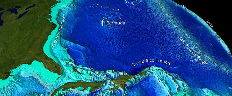
The most extended mountain range on our planet is not the Andes, Rockies, or Himalayas. It is the mid-ocean ridge, an interconnected system of underwater peaks that traverses every ocean basin and encircles the globe like stitching on a ball. According to NOAA’s National Ocean Service, it is the longest mountain range on Earth, stretching 40,389 miles, or approximately 65,000 kilometers.
Initially, this fact seems incorrect because the range is primarily unseen. Mountains are typically visible from valleys, crossed by roads, ascended by climbers, and captured in photographs against the sky. The mid-ocean ridge lies under kilometers of seawater. Its peaks and rift valleys aren’t obscured by distance, but rather by an entire ocean.
NOAA approximates that about 90 percent of the ridge system is located beneath the ocean. Only a few rare locations, such as Iceland, bring a portion of the ridge above sea level. The majority remains a submerged, planet-scale landscape understood by humans through sonar, satellite gravity data, deep-sea vehicles, and sporadic glimpses from remotely operated cameras.
A mountain chain created by spreading plates
The ridge exists because the Earth is constantly in motion. At divergent plate boundaries, tectonic plates separate, and hot material ascends from the mantle. When magma reaches the seafloor and cools, it forms new oceanic crust. The outcome is a lengthy, volcanic mountain range that indicates the renewal of the ocean floor.
The U.S. Geological Survey clarifies that divergent boundaries produce new crust as plates drift away from one another. The Mid-Atlantic Ridge is one segment of this global system, extending from the Arctic Ocean through the Atlantic and past the southern tip of Africa. Other connected ridges continue through the Indian, Pacific, Southern, and Arctic oceans.
Seen on a global map, the ridge is not straight. It curves, offsets, and branches where spreading centers intersect transform faults and other plate boundaries. USGS has likened the ridge’s trace to the seam on a baseball, a straightforward analogy for a complex planetary formation.
The highest points aren’t always the pinnacle
On land, mountain ranges are frequently assessed by their tallest peaks. The Himalayas captivate the imagination because Everest stands so far above sea level. The mid-ocean ridge warrants a different metric. Its significance lies not in a single summit but in its continuity, length, and geological dynamism.
A typical ridge crest may sit thousands of meters below the surface and still rise significantly above the adjacent abyssal plain. NOAA indicates that the system comprises mountains and valleys created as plates separate and magma occupies the gap. To the ocean, these are not trivial folds; they constitute the framework of the seafloor.
The ridge is also volcanic. The same NOAA account describes the global mid-ocean ridge system as the largest singular volcanic feature on the planet, consisting of thousands of individual volcanoes or volcanic ridge segments. The eruptions are usually concealed from human sight, yet they are part of the mechanism that continually reconstructs the ocean crust.
Why it remained obscured for so long
Humans charted coastlines long before they comprehended the deep seafloor. For most of history, the ocean floor was envisioned as relatively uniform: a dark, muddy expanse beneath shipping routes and fishing grounds. The actual configuration of the seafloor emerged gradually through sounding lines, echo sounders, wartime sonar, and postwar oceanographic surveys.
The challenge isn’t merely depth. Light vanishes rapidly underwater. Pressure increases by roughly one atmosphere every 10 meters. Saltwater deteriorates equipment. Ships navigate slowly. Sonar mapping requires time, and visual exploration demands vehicles capable of enduring darkness, cold, and immense pressure.
That is why the ridge can be both the longest mountain range on Earth and a place few will ever witness firsthand. One can fly over the Himalayas, drive near the Andes, or hike into the Rockies. To explore most of the mid-ocean ridge, they require a research vessel, a submersible, an ROV, and significant logistical support.
A world still largely unseen
The obscurity isn’t poetic embellishment. NOAA Ocean Exploration states that only 28.7 percent of the global seafloor had been mapped with modern high-resolution technology as of April 2026. Satellite-derived maps provide a broad overview of the entire ocean floor, but they lack detail. They can suggest large features while overlooking smaller seamounts, faults, vents, and habitats.
Visual exploration is even more restricted. The same NOAA page notes that explorers have visually observed less than 0.001 percent of the deep ocean seafloor. This means the longest mountain range on Earth traverses a domain that is outlined but scarcely seen by human eyes or cameras.
This is vital because the ridge is not merely rock. Mid-ocean ridges are home to hydrothermal vents, chemical gradients, microbial communities, and bizarre creatures adapted to darkness and pressure. Some ecosystems around vents derive energy not from sunlight but from chemical reactions involving fluids heated by the Earth’s interior.